UplandHntr

Member
May 4, 2009
19
0
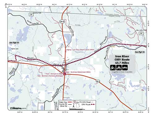
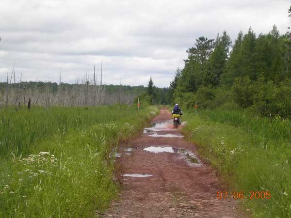
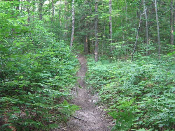
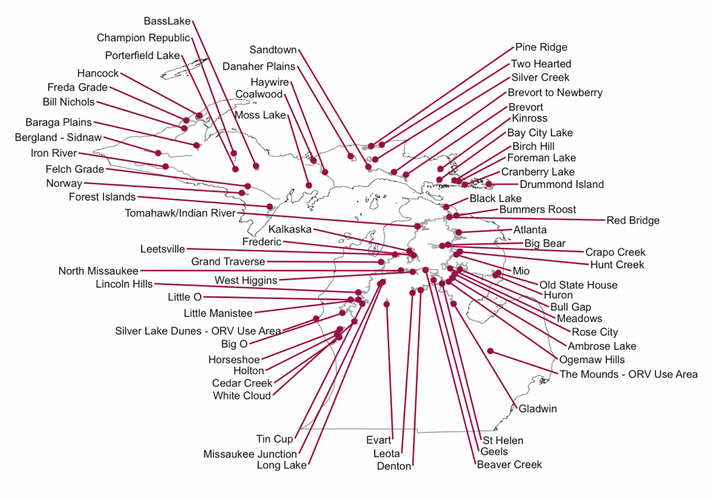
I was up in the UP / Watersmeet area last weekend trying to ride some trails with my 2 boys. I was thoroughly confused as to what trails were open and just finding new trails in general. Very few are connected, the ones I found were short and just leaf covered wide flat trails.
It was disappointing.
Any thoughts on riding the Watersmeet area or North or East? It would be nice to go out for a couple of hours and not have to double back after 2 miles to load back up to head to the next area. I stopped at the Tourism place and the DNR office and Headwaters Polaris in Watersmeet without much success.
 

Steve St.Laurent

Mi. Trail Riders
Member
Feb 6, 2006
255
0
It sounds like you were riding unmarked trails/two tracks. Here is a link to the DNR site where all the trail maps are located: http://www.michigan.gov/dnr/0,1607,7-153-10365_15070-38330--,00.html . Here's a link to a trail that goes right by Watersmeet - http://www.midnr.com/publications/p...ORV/Maps-Trail/iron_river-marenisco_route.pdf - it's 67 miles long. That's a "route" so it's wide enough for jeeps to go down. If your looking for motorcycle trail you'll want to head over to Porterfield ( http://www.midnr.com/publications/p...V/Maps-Trail/porterfield_motorcycle_trail.pdf - about 75 miles away from Watersmeet) or Bass Lake ( http://www.midnr.com/publications/pdfs/forestslandwater/ORV/Maps-Trail/bass_lake_motorcycle.pdf - about 113 miles away).
 

Steve St.Laurent

Mi. Trail Riders
Member
Feb 6, 2006
255
0

KTM Mike

~SPONSOR~
Mi. Trail Riders
Apr 9, 2001
2,086
0
FWIW - in the UP, on state land, it is open unless posted closed.
 

2TrakR

~SPONSOR~
Mi. Trail Riders
Jan 1, 2002
794
0
FWIW - in the UP, on state land, it is open unless posted closed.
Correct, but near Watersmeet is National Forest. They have gone to close unless posted on their MVUM (Motor Vehicle Use Map). They have a number of roads that are open, BUT, most of them are all dead-ends (as it sounds like the OP has found).

Any thoughts on riding the Watersmeet area or North or East?
What type of riding are you looking for?
As stated, there are several ORV Routes nearby (which are old RR Grades & shared snowmobile trails). The Iron River ORV Route crosses through Watersmeet:
http://www.vvmapping.com/trails/ironRiver.html
ORVTrailBook54.jpg

IronRiverRoute2.jpg


Nearest "loop" Trail would be Baraga. Not single track, but not all road-width either. Porterfield and Bass Lake (as indicated by others) would be the closest cycle-only single track trails.
http://www.vvmapping.com/trails/bassLake.html
BassLake1.jpg
 

UplandHntr

Member
May 4, 2009
19
0
I just dont want a 10 mile straight trail/old RR grade. Thats not much fun on a dirtbike.
Im open to anything else really

State vs. National Forest-interesting. So any state land is open unless its posted otherwise. I guess I'll have to research that in the area. Those maps from the National Forest folks is very hard to read-and way too big.

Good info fella's, keep it coming.
 

KTM Mike

~SPONSOR~
Mi. Trail Riders
Apr 9, 2001
2,086
0
UplandHntr said:
So any state land is open unless its posted otherwise. I guess I'll have to research that in the area. .

That applies only in the U.P. of Michigan. Only on existing trails (ie you cant just go bush whack with no trail) Lower Peninsula is Closed unless posted open (Are you confused yet?)
 

UplandHntr

Member
May 4, 2009
19
0
KTM Mike said:
That applies only in the U.P. of Michigan. Only on existing trails (ie you cant just go bush whack with no trail) Lower Peninsula is Closed unless posted open (Are you confused yet?)

getting close :yikes:
I guess I would need to know whats defined as a trail on state land. Any single track or is there a map for that too? :yikes:
 

2TrakR

~SPONSOR~
Mi. Trail Riders
Jan 1, 2002
794
0
Here's the full description:
http://www.vvmapping.com/trails/trailLegal.html

Summary for UP:
USFS Land - Closed unless shown on their MVUM. Not any actual trails on USFS land in the UP (one to be added soon), but lots of narrow roads.
State Land - Open unless posted closed. This pertains to _roads_. A Trail is considered anything less than 50" in width. "Trails" are only open if posted as open, ie "designated". Put another way, a trail requires the orange ORV triangle to be posted on/along the trail.

Designated is with orange triangles:

ORVTR_MIDNR.gif
(cycle/ATV)

ORVcycleTR_MIDNR.gif
(cycle)

ORVRT_MIDNR.gif
(route = all orvs including full-size vehicles)

miORVLocations.gif


Nearest "trail" is Baraga. Nearest single track is Porterfield.

This Trail Guide depicts which trails are cycle or ATV or full size (cycle would most likely be single track): http://www.vvmapping.com/trails/trailInfoMI.html
 

UplandHntr

Member
May 4, 2009
19
0
bumpity bump..
any thoughts guys? Can someone give me any address to punch into my GPS to know how to find Baraga?

Any state land in Iron Co that may be open to riding?

Sure looks like a great weekend to be out riding! :nod:
 

katoom125

Member
Apr 25, 2004
355
1
UplandHntr said:
bumpity bump..
any thoughts guys? Can someone give me any address to punch into my GPS to know how to find Baraga?

Any state land in Iron Co that may be open to riding?

Sure looks like a great weekend to be out riding! :nod:

according to one of my maps - the parking/trailhead for Barage Plains (if that's what you want for the GPS) is:
N46 37.170
W88 36.610

last time I was there (few years ago) it was pretty open riding.

we'll be further east (newberry and Kinross areas) this coming weekend and yes, the weather looks great!
 

katoom125

Member
Apr 25, 2004
355
1
UplandHntr said:
Hmm
whats open riding?
open fields and flat?

Well?? taking your Jeep probably wouldn't have been out of the question - yes, mostly flat and wide - follows a lot of the woods lines but not much single track thru the woods for sure.

maybe it's changed tho?
 
Top Bottom