Nestrick

Mi. Trail Riders
Member
Aug 6, 2003
215
0
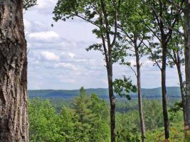
Tuesday was a gorgeous, sunny, warm, summer day. The deep blue sky was filled with puffy white clouds, just a touch of a breeze out of the west … too nice a day to waste on yard work, so off I went to ride the Kalkaska Trail C Loop. This section of the Kalkaska system is the southernmost loop which starts at the Trailhead parking facility located a few miles west of Grayling on M-72. The C Loop is approximately 31 miles in length and is 50” trail suitable for ATVs and motorcycles. Although reasonably wide in most sections, after all the rain we have endured this spring, this trail has many challenges to keep riders of all skill levels interested.

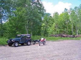
I arrived at the trailhead around 1345 hrs to find it empty of visitors and apparently under rehabilitative construction. The parking lot has been recently graded and there are many tree stumps piled around the perimeter. A functional, but not very clean, restroom is available. [See photo below, left]

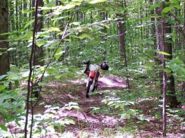
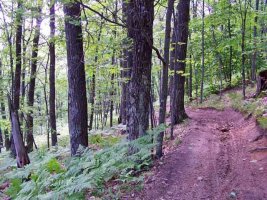
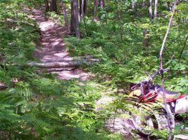
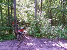
After quickly unloading and gearing up for the ride, I took off in the CCW direction as past experience has taught me that the steepest hill climbs are encountered by traveling in this direction. Basically the trail has three separate sections. Beginning at the trailhead and proceeding south [CCW] to point #12 on the MI DNR map you pass through heavily wooded and hilly terrain that is relatively easy to ride … I found the trails to have many puddles and muddy spots but nothing serious. Because trail composition for most of this section is a sandy loam, the surface was basically hard with excellent traction so the going was relatively fast. Erosion is evident on many of the hill sides, but the trail is not heavily grooved or washed out. Tree roots eroded free of soil but still covered with slick mud are the greatest obstacles to be overcome … the forest is almost fully in bloom … the leaves are fresh, large and very green. Vines are beginning to creep into the trail in the brushy areas and the thorns are beginning to emerge which makes long sleeves a desirable item if you want to ride at speed and return with any skin left on your arms. [See photo below, right]
 

Attachments

  • 100_0297_edited-web-#1.jpg
    100_0297_edited-web-#1.jpg
    61.8 KB · Views: 182
  • 100_0300_edited-web-#2.jpg
    100_0300_edited-web-#2.jpg
    48.4 KB · Views: 196

Nestrick

Mi. Trail Riders
Member
Aug 6, 2003
215
0
Having proceeded to the southernmost portion of the loop, near the area indicated on the MI DNR map as #12, the terrain begins to change dramatically. You exit the dense hardwood stands and pass through a swampy area that is mostly forested with conifer. There are several large ponds [small lakes] evident to the side of the trail … some within feet of your passage … on this day the singing of frogs was so loud it was nearly impossible to hear anything else in the vicinity! In addition, the trail composition begins to change from a sandy loam to pure sand … the transition is subtle … it begins as a shallow, sandy base that is relatively hard, and rapidly becomes deep, fine, soft, loose sand with many large whoops. One section of whoops is more than a half mile in length … the good news is that the trail is reasonably open with few trees or obstacles to contend with other than the deep sand whoops … so, hard on the throttle, up on the pegs and back on the seat … then for me, pull over and rest! Following the sandy section one begins to climb back into ridge country … interestingly, the trail meanders along the sides of large ridges for a considerable distance … while not difficult to ride, the views are spectacular and I had a hard time keeping my eyes on the trail. [See photo below, left]

Soon the trail begins to switchback … down one side of a ridge and up the next. Surface composition remains mostly sand, sometimes a bit harder but mostly, soft and loose. At one sharp turn immediately following a steep incline I ran into an obstacle composed of three trees lying parallel across the trail … they were spaced about one wheel diameter apart and were approximately 10 inches OD and elevated off the ground about 6 inches. Now I know you guys wouldn’t even have slowed down for this … or even worse, would have gone out of your way to ride over it … but not me. First I tried to move them … too heavy … then I looked for a way around, found one and took the easy way out! [See photo below, right]
 

Attachments

  • 100_0310_edited-web-#3.jpg
    100_0310_edited-web-#3.jpg
    73.2 KB · Views: 190
  • 100_0312_edited-web-#4.jpg
    100_0312_edited-web-#4.jpg
    49.3 KB · Views: 187

Nestrick

Mi. Trail Riders
Member
Aug 6, 2003
215
0
Before reaching the M-72 crossing on the east side of the loop going in a northerly direction one begins cresting some very large hills. The scenery is amazing … you can see several miles in the distance and there is no evidence of civilization in the picture … just continuous, deeply wooded territory. [See photo below, left] I picked one of these areas for my rest break … broke out the water and snack bars, found a stump and absorbed the environs … good for the soul! Watched an eagle circling high above … seemed to never flap his wings … just rode the steady breeze almost defiant of gravity.

Continued riding north eventually brings one to MI DNR map point #2. This portion of the ride begins what I feel is the whole reason for coming here … the really steep hills. None of the trail is flat from here back to the trailhead parking facility. Some of the hills are pure sand-based, others are sandy in some areas and hard pack in others … most are not short in duration and some are amazingly long and complex. Try as I could, I failed to photographically capture the steepness of any of these ascents and descents … often the twists in the trail hide portions from ones sight at either the top or bottom … most of these I did not feel comfortable stopping in the middle as momentum was definitely a plus due to the steepness of the inclines.

By the time one reaches the portion of the trail that repeatedly intersects the ORV Route passing through the area, the trail has returned to a gummy loam passing through dense hardwood stands. The hills in this area are, in my opinion, considerably challenging … especially when relatively wet as I found them to be. Erosion has produced a profusion of roots across the trail … on steep inclines the soil has been washed away completely leaving a large obstacle in the form of a root that must be traversed while under strong throttle in order to make the grade … the problem I found was that these roots were often in series and seldom crossed the trail perpendicular to my route … trying to keep the front end down while under strong throttle and not let it tuck when jounced off a root not hit squarely was an entirely new experience for me … I learned fast! The more I practiced, the better my control. Believe me, there are some long, twisty hills in this area … that when slippery, will challenge your riding skills as well as your front tube. In some places the trail rode as though it were considerably narrower than its actual dimension due to the line one was forced to follow in order to stay away from the worst of the obstacles. The undergrowth in this section of the Loop is also filling in nicely as indicated in the last picture which was taken at one of the ORV trail and route intersections. [See photo below, right]

This ride required 2.9 hours of motor time and approximately 1.5 gallons of fuel for my CRF-450. I was tired on its completion despite a 15 to 20 minute break in the middle of the run. The hilly section coming across the northernmost portion of the loop returning to the trail head was the most physically demanding part of the ride excepting the half mile section of deep sand whoops. This was a great ride … my legs are sore today [day after the ride] … a sign that I spent a great deal more time on the pegs than in the seat. If that’s your forte, then the Kalkaska C Loop is for you!

terry nestrick :cool:
 

Attachments

  • 100_0316_edited-web-#5.jpg
    100_0316_edited-web-#5.jpg
    59.2 KB · Views: 169
  • 100_0318_edited-web-#6.jpg
    100_0318_edited-web-#6.jpg
    50.6 KB · Views: 178

WildBill

~SPONSOR~
Mi. Trail Riders
Mar 29, 2002
281
0
Another great Nestrick trail report! But wait there's more. Now with pics included. Thanks for the write up Terry. With no plans to ride in the next 3 weekends, it's great to ride vicariously through you. Ride on!
 

YZMAN400

Member
Dec 2, 2003
2,491
0
Thanks for the writeup Terry. A few of my friends from the West Michigan Trail Riders were up there last weekend along with a few of the Pathfinders. They were scouting trail for the fall color tour. Looks like they are gonna have a good time there this fall.

I was gonna go with them last weekend but chose to stay home and be domestic. Looks like I made the wrong choice.
 

Tom Dixon

Farmer Tom = Face Planter
Mi. Trail Riders
LIFETIME SPONSOR
Nov 15, 2001
872
0
I ride that trail quite a bit. It is pretty fun when wet. I was out there Sunday, and it poured for close to a half hour straight. Nice pics too.
 

Welcome to DRN

No trolls, no cliques, no spam & newb friendly. Do it.

Top Bottom