BSWIFT

Sponsoring Member
N. Texas SP
LIFETIME SPONSOR
Nov 25, 1999
7,926
43
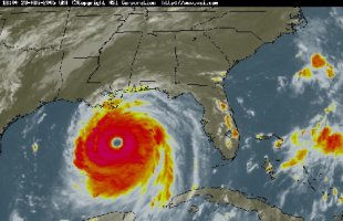
To all or our DRN brothers and sisters on the Gulf Coast, take cover and let us know that you and yours are OK in a few days. This looks to be one of the worst storms on record. Let us know if we can help!
Moteaux, Phillip, evenslower, D'lefleur....check in......
 

Okiewan

Admin
Dec 31, 1969
29,550
2,238
Texas
Ditto

Looks to be the worst of a lifetime... full-on mandatory evacuation of New Orleans, President is supposed to comment on it in 30 minutes. They are talking about the Big Easy under 20 feet of water.

Good luck to everyone down there. I was wondering about Randy, but I just heard all the rigs are evacuated as well.
 

Tony Eeds

Godspeed Tony.
N. Texas SP
Jun 9, 2002
9,535
0
Ditto on checking in everyone! This one appears to be that once in a century storm.

WTNT32 KNHC 281737
TCPAT2
BULLETIN
HURRICANE KATRINA INTERMEDIATE ADVISORY NUMBER 23A
NWS TPC/NATIONAL HURRICANE CENTER MIAMI FL
1 PM CDT SUN AUG 28 2005

...POTENTIALLY CATASTROPHIC HURRICANE KATRINA MENACING THE NORTHERN
GULF COAST...

A HURRICANE WARNING IS IN EFFECT FOR THE NORTH CENTRAL GULF COAST
FROM MORGAN CITY LOUISIANA EASTWARD TO THE ALABAMA/FLORIDA
BORDER...INCLUDING THE CITY OF NEW ORLEANS AND LAKE PONTCHARTRAIN.
A HURRICANE WARNING MEANS THAT HURRICANE CONDITIONS ARE EXPECTED
WITHIN THE WARNING AREA WITHIN THE NEXT 24 HOURS. PREPARATIONS TO
PROTECT LIFE AND PROPERTY SHOULD BE RUSHED TO COMPLETION.

A TROPICAL STORM WARNING AND A HURRICANE WATCH ARE IN EFFECT FROM
EAST OF THE ALABAMA/FLORIDA BORDER TO DESTIN FLORIDA...AND FROM
WEST OF MORGAN CITY TO INTRACOASTAL CITY LOUISIANA. A TROPICAL
STORM WARNING MEANS THAT TROPICAL STORM CONDITIONS ARE EXPECTED
WITHIN THE WARNING AREA WITHIN THE NEXT 24 HOURS. A HURRICANE WATCH
MEANS THAT HURRICANE CONDITIONS ARE POSSIBLE WITHIN THE WATCH
AREA...GENERALLY WITHIN 36 HOURS.

A TROPICAL STORM WARNING IS ALSO IN EFFECT FROM DESTIN FLORIDA
EASTWARD TO INDIAN PASS FLORIDA...AND FROM INTRACOASTAL CITY
LOUISIANA WESTWARD TO CAMERON LOUISIANA.

FOR STORM INFORMATION SPECIFIC TO YOUR AREA...INCLUDING POSSIBLE
INLAND WATCHES AND WARNINGS...PLEASE MONITOR PRODUCTS ISSUED
BY YOUR LOCAL WEATHER OFFICE.

AT 1 PM CDT...1800Z...THE CENTER OF HURRICANE KATRINA WAS LOCATED
NEAR LATITUDE 26.5 NORTH... LONGITUDE 88.6 WEST OR ABOUT 180 MILES
SOUTH-SOUTHEAST OF THE MOUTH OF THE MISSISSIPPI RIVER.

KATRINA IS MOVING TOWARD THE NORTHWEST NEAR 13 MPH...AND A TURN
TOWARD THE NORTH-NORTHWEST IS EXPECTED OVER THE NEXT 24 HOURS.

MAXIMUM SUSTAINED WINDS ARE NEAR 175 MPH...WITH HIGHER GUSTS.
KATRINA IS A POTENTIALLY CATASTROPHIC CATEGORY FIVE HURRICANE ON
THE SAFFIR-SIMPSON SCALE. SOME FLUCTUATIONS IN STRENGTH ARE LIKELY
DURING THE NEXT 24 HOURS.

HURRICANE FORCE WINDS EXTEND OUTWARD UP TO 105 MILES FROM THE
CENTER...AND TROPICAL STORM FORCE WINDS EXTEND OUTWARD UP
TO 205 MILES.

THE ESTIMATED MINIMUM CENTRAL PRESSURE IS 906 MB...26.75 INCHES.

COASTAL STORM SURGE FLOODING OF 18 TO 22 FEET ABOVE NORMAL TIDE
LEVELS...LOCALLY AS HIGH AS 28 FEET ALONG WITH LARGE AND DANGEROUS
BATTERING WAVES...CAN BE EXPECTED NEAR AND TO THE EAST OF WHERE THE
CENTER MAKES LANDFALL. SIGNIFICANT STORM SURGE FLOODING WILL OCCUR
ELSEWHERE ALONG THE CENTRAL AND NORTHEASTERN GULF OF MEXICO COAST.

RAINFALL TOTALS OF 5 TO 10 INCHES...WITH ISOLATED MAXIMUM AMOUNTS OF
15 INCHES...ARE POSSIBLE ALONG THE PATH OF KATRINA ACROSS THE GULF
COAST AND THE TENNESSEE VALLEY. RAINFALL TOTALS OF 4 TO 8 INCHES
ARE POSSIBLE ACROSS THE OHIO VALLEY INTO THE EASTERN GREAT LAKES
REGION TUESDAY AND WEDNESDAY.

ISOLATED TORNADOES WILL BE POSSIBLE BEGINNING THIS EVENING OVER
SOUTHERN PORTIONS OF LOUISIANA...MISSISSIPPI...AND ALABAMA...AND
OVER THE FLORIDA PANHANDLE.

REPEATING THE 1 PM CDT POSITION...26.5 N... 88.6 W. MOVEMENT
TOWARD...NORTHWEST NEAR 13 MPH. MAXIMUM SUSTAINED WINDS...
175 MPH. MINIMUM CENTRAL PRESSURE... 906 MB.

THE NEXT ADVISORY WILL BE ISSUED BY THE NATIONAL HURRICANE CENTER AT
4 PM CDT.

FORECASTER PASCH

The gang from Louisiana that I know of ...
D Lafleur
Dewster
evenslower
Greg Guidry
holeshotedh
Jon K.
junkjeeps
LaRider20
mafols
Moteaux
Philip
rjl40

Whom am I missing?

The folks on the east side of the eye are the ones that will get the brunt of the storm.

IR Image
 

Attachments

  • katrina.jpg
    katrina.jpg
    58.9 KB · Views: 270
Last edited:

Patman

Pantless Wonder
LIFETIME SPONSOR
Dec 26, 1999
19,765
1
Good luck guys! Stay safe and hopefully dry.
 

a454elk

Mexicutioner
LIFETIME SPONSOR
Jun 5, 2001
7,529
18
Godspeed to you all, hang tight!
 

Tony Eeds

Godspeed Tony.
N. Texas SP
Jun 9, 2002
9,535
0
I heard from Randy.

He was evacuated out of the Gulf on Saturday and is laying low at home, which is a few miles NW of Lafayette.
 

BSWIFT

Sponsoring Member
N. Texas SP
LIFETIME SPONSOR
Nov 25, 1999
7,926
43
Tony Eeds said:
I heard from Randy.

He was evacuated out of the Gulf on Saturday and is laying low at home, which is a few miles NW of Lafayette.
Thanks for the update, Tony!
 

CaptainObvious

Formally known as RV6Junkie
Damn Yankees
LIFETIME SPONSOR
Jan 8, 2000
3,331
1
Stay safe. Look for high and dry land.
 

evenslower

~SPONSOR~
N. Texas SP
Nov 7, 2001
1,234
0
Thanks for thinking of us.

At the moment our house is an evacuation center for family from New Orleans, Houma and folks who live on the coast. Let's just hope these folks have a home to go back to.

We should be OK in Baton Rouge but I'd sure rather be at the 500!!!!!!!
 

BSWIFT

Sponsoring Member
N. Texas SP
LIFETIME SPONSOR
Nov 25, 1999
7,926
43
evenslower said:
Thanks for thinking of us.

We should be OK in Baton Rouge but I'd sure rather be at the 500!!!!!!!
We would rather you be here, too! Keep us up to date and hug the girls for us!
 

oldguy

Always Broken
Dec 26, 1999
9,411
0
I acn not imagine waiting for something like this to come in. Keep safe and know the northern DRN family is hoping you ride this out safely. Can't wait to hear the cajun version at DW "Dis storm it blew right on in and .......................
 

JPIVEY

Sponsoring Member<br>Club Moderator
LIFETIME SPONSOR
Mar 9, 2001
3,177
0
You'll be in our prayers, as well as everyone else in the track of this monster,

This is terrible :(
 

Gigalabz

Member
Aug 28, 2005
4
0
Yea man...i live in starkville, ms which is somewhat inland but its still a catagory 5 storm...wayyyy dangerous. Their saying that its "Bigger then andrew ever thought of being"...
 

Moteaux

Professional Mud Tester
LIFETIME SPONSOR
Aug 30, 2001
1,524
0
Almost 9 am and Lafayette is relatively unscathed at this point. Light rains and slightly increased wind. I am a good 2 hours NW of New Orleans.

I was evacuated off the rig on Sat. morning. I was working about an hours boat ride south of Grand Isle right where the storm headed inland. I will find out soon whether or not I have a rig to go back to!

Anyway, as for you watching the storm and radar, DLafleurs family and I are apparently well out of harms way. We should ony get some rain and increased winds. The others you mentioned like LARider20, Greg Guidry, JunkJeeps and others are more apt to have damage than me. Keep safe brothers!!!

Thanks for all the well wishes and will update if/when I can. I may be headed back out to the Gulf tomorrow depending on damage etc.. I am sure Darin is busy as can be with all his assets in the Gulf so you may not hear from him.

Also, to all our Mississippi and Alabama neighbors. Keep safe and you are in our thoughts and prayers.

Randy aka Moteaux
 

D Lafleur

LIFETIME SPONSOR
Dec 11, 2001
610
0
Just an update at 10:45, everyone at home is safe. I am at work right now, 9th floor office building in Lafayette, LA and the the wind has really started picking up. The reflections in the glass are shaking. We should be ok here. We are presently working on the resurrection plans for the Gulf of Mexico oil and gas production.

I hate to be the one with bad news, but buy your gas and oil products today. Based on Hurricane Andrew and Ivan, this one will have a significant impact to the oil and gas supplies. The products produced in the Gulf as well as the Imports. The only terminal in the southern US that handles Super Tankers had the eye pass right over.

Thanks to everyone for their prayers and mine go out to the people in the New Orleans area and MS and AL. This storm is going to cause trouble in every area that it passes. This is the storm that will make the History books.

Darin.
 

squeaky

Roosta's Princess
Damn Yankees
LIFETIME SPONSOR
Mar 28, 2003
2,561
0
This is so scary and terrible...Buckle down and stay safe everyone that may be affected by this storm. You are in my thoughts. Try to keep in touch and let us all know how things work out for you.
 

Tony Eeds

Godspeed Tony.
N. Texas SP
Jun 9, 2002
9,535
0
Katrina skins Superdome (photo)

10:30 a.m. - This shot, taken from the third-floor roof of the Times-Picayune building during a slight break in the rain, shows where Hurricane Katrina's winds ripped away a large portion of the white covering of the Superdome on Monday morning.
(NOLA Photo by Jon Donley)
 

Attachments

  • dome.jpg
    dome.jpg
    39.8 KB · Views: 150

BSWIFT

Sponsoring Member
N. Texas SP
LIFETIME SPONSOR
Nov 25, 1999
7,926
43
Good to hear from you guys!
 

Moteaux

Professional Mud Tester
LIFETIME SPONSOR
Aug 30, 2001
1,524
0
Okiewan said:
Yo Randy.. we are going to be graced by your company at DW, yes?

As much as I hate to say, I don't think so this year. Lucas most likely will not be coming as he will be a newly wed at that time, Dr. Mike has moved up to the Birmingham, AL area and Darin hasn't talked about it either. I haven't seen much of him since I have been so busy with work.
 

D Lafleur

LIFETIME SPONSOR
Dec 11, 2001
610
0
I am up in the air at this time also. I was planning on bringing the family for a DW experiance, but Katrina may have just put a hole in that plan and my ISDE plans. It isnt good in LA.
 

JPIVEY

Sponsoring Member<br>Club Moderator
LIFETIME SPONSOR
Mar 9, 2001
3,177
0
So what's the lastest, I understand that even though Katrina has gone North there is still a lot of flooding going on today in place that weren't flooded yesterday

Is everybody still safe ??...........
 

Welcome to DRN

No trolls, no cliques, no spam & newb friendly. Do it.

Top Bottom