duckboy

Member
Jan 9, 2005
200
0
Good news I argued with the dnr today! Did you know the dnr maps don't distinguish between atv and cycle trails? Well neither did they.

It started out innocently enough when I stopped by the local dnr office to get a state park sticker. I asked the lady behind the counter if she knew why the maps weren't marked to distinguish between atv and cycle trails. She didn't know anything about orv trail maps. But she knew who did and gave me my state park sticker with a sticky note on the back with a name and phone number of the guy who would. So I called and left him a message.

Steve from the Lansing office called me at 10:45 this morning and I explained my question to him. He insisted I was wrong and told me he was looking at the maps online as we were speaking. I pointed out maps that had both atv and cycle trails on the same map with no way to disern the difference. I explained that the legend on the map says that all the trails are 50" when only the atv trails are 50" and there's no way to tell this with the map. He said " it does say 50" or less ". As if it's OK that a 42" quad can't fit if a 33" dirtbike can when the map says it's an atv trail. :bang: It became to both of us apparent that neither of us were going to budge so we decided to end the call before anyone.

It must have got him thinking because he called me back and said he had just talked to the legal department about the wording in the map legends. He did mention that he was not looking at maps when I talked to him earlier and that he was going to look into getting the maps corrected. It wasn't an apology, but I got the feeling he couldn't for legal reasons. Either way I was estatict and I stopped thinking about the smear compaign I was planning in my head since his first call.

Having the maps marked correctly will help with quads on the cycle trails and help people planning riding trips as to where they can ride their quads without the trial and error method. I often rode with people who couldn't ride a bike in the deep sand so they rode a quad. It was frustrating trying to find new trails we could both ride, so I hope getting the maps corrected will everyone.:yeehaw:
 

duckboy

Member
Jan 9, 2005
200
0
It's not just a problem with one map. Evart, Missaukee, Long Lake and Lincoln Hills are all cycle trails but say offroad cycle and or atv. The best example of four different types of trails is the Lincoln Hills, Tin Cup Springs, and Little Manistee with some of the Little O. It has all four types of trails but only accurately distinguishes the orv route and mcct trail. The offroad cycle trails and atv trails are marked the same way. So how can you tell by looking at the map? You can't, it needs to be marked better. These are just some of the ones I know of I haven't been on all the trails.
 

team-green32

MAGA
Mi. Trail Riders
Member
Mar 27, 2001
395
0
Chicago
There is an old saying, "There are no large victorys, without the tiny battles won."
 

katoom125

Member
Apr 25, 2004
355
1
great work!
Maybe it will help keep those 4 legged creatures off the single track and on their own trails - better for all of us.
thanks!
 

2TrakR

~SPONSOR~
Mi. Trail Riders
Jan 1, 2002
794
0
duckboy said:
It's not just a problem with one map. Evart, Missaukee, Long Lake and Lincoln Hills are all cycle trails but say offroad cycle and or atv.

Some examples:
Evart is open to all ORVs under 50" in width; however if that ORV cannot traverse the trail without leaving the trail or running over trees, they can't go on it - otherwise if they can fit, it's legal. At the same time Evart is maintained to 40" specs and this is noted in the legend (just has picture of a cycle, not an ATV).
Missaukee & Long Lake are both in the same category.
Lincoln Hills better fits your issue in that each trail has different maintenance specs and they are not distinguished by anything on the map. However, the DNR map is still accurate as some trails depicted are suitable for ATVs.

The DNR maps are correct and "true" in what they depict. Unfortunately this has been an issue because they do not clearly tell the User which trail is better suited to ATV use. From the DNR perspective, what is in the legend and depicted on the maps is completely accurate and meets the legal definitions. From an ORV operators' perspective those maps to not clearly define actual ground conditions.

As the law stands, there is no such thing as ATV or Cycle trail. It's all ORV trail and ORV trail is defined as accessible to ORVs less than 50" in width. At the same time, it does not say that a 49" ORV may be able to traverse all ORV trails nor does it say all trails are 50 inches wide. See the loophole?

I had a good discussion with fellow riders this winter about "Cycle" and ATV trail (even talked to Steve K about it too; his answer was very political though). The other riders were adamant that Steve said "no more cycle trail" at some ORV Board meeting several years ago. They took this to mean no more trail less than 50" wide AND maintained to that width. Of course, this is not what he said, he only said there "was no [more] Cycle trail" which hasn't technically existed since the ORV program was put into place in the early 90s. Technically all trail has been ORV trail since the program was put into place. That doesn't preclude the Department from maintaining trails at 40" just as it doesn't force them to maintain all trails at 50".

I don't know what your discussion with Steve included, but the most beneficial outcome would be inclusion of the maintenance specification on each map for each trail. This would inform Users how wide they should expect a given trail to be.
 

YZMAN400

Member
Dec 2, 2003
2,491
0
Speaking of maps. I was at Bills Honda the other day and they have an Atlas style map book there of all the trails in Michigan. It has info in there on the DNR rules of the trail, Safety training, and other usefull information. It dosn't apear to be put out by the CCC or the DNR. I was looking for a publisher info on it but couldn't come up with anything. It was like $18. The book was like 12"w x 16" tall. I have a CCC book from last year and this dosn't look anythink like that. It was more like a DeLorme style mapbook.
 

2TrakR

~SPONSOR~
Mi. Trail Riders
Jan 1, 2002
794
0
YZMAN400 said:
Speaking of maps. I was at Bills Honda the other day and they have an Atlas style map book there of all the trails in Michigan. It has info in there on the DNR rules of the trail, Safety training, and other usefull information.
Saw those last week myself at another dealer. Had a few minutes to browse through it while waiting for my parts to be found..
It looks very nice and has lots of great info. I think it's 11x17 but regardless, it's "large" format like you say. The maps are direct copies of the DNR maps, so if you don't have access to a wide format printer, it's a nice way of getting larger trail maps. Of course, if you do have a bigger printer or don't mind regular sized paper maps, then you can print your own for free.
The information looked nice regarding ORV regs; didn't see anything that's not in the DNR handbook, but didn't dig into the detail.
The book only has the lower peninsula maps, or at least the ones I saw were that way.
The publisher is Off Road Ventures who is affiliated with the Michigan ATV Association. I've been lead to believe the President of that organization is running this Off Road Ventures company.
Certainly looked like a nice product for the new or inexperienced ORV consumer.
 

YZMAN400

Member
Dec 2, 2003
2,491
0
Bills Honda said that they have had people asking about trail maps in the past and had no way of helping them. When they saw this map book it was just what they had been looking for.

Now that I think of it I am supprised that the CCC dosn't have there map books for sale at the dealerships. Yea you get the mapbook free with membership. But I am sure that there are people out there that dont want the membership and just want the mapbooks. Yes we can print maps off from the DNR's site or order a set thru the snail mail. But not everyone is as I-net savy as us. Plus most dealers probably arn't aware of what website to direct customers to were they can get the maps. Might be another way for the CCC to make some $ on the side.
 

2TrakR

~SPONSOR~
Mi. Trail Riders
Jan 1, 2002
794
0
YZMAN400 said:
Now that I think of it I am supprised that the CCC dosn't have there map books for sale at the dealerships. Might be another way for the CCC to make some $ on the side.

Very true. I think our non-profit status prevents us from making a profit (ie selling an item). With the old mapbook, the map base was copyrighted from another company and our license prevented re-sale of that map. That last part no longer applies to our map base.
We've discussed why the old book wasn't sold but nothing about selling the new one.
 

duckboy

Member
Jan 9, 2005
200
0
2trakR,
Look at this map.
http://www.dnr.state.mi.us/spatialdatalibrary/pdf_maps/trail_maps/orv/evart.pdf
Where does it say 40"? Also explain why they combined cycle trails and atv trails all the dnr maps but clearly defines a difference on page 12 of the dnr Michigan's Off-Road Vehicle Guide. Page 11 in the online version.
http://www.michigan.gov/documents/ORVguide_95964_7.pdf
Also Steve at the lansing office said Evart is a cycle only trail and it is illegal to ride atv's there. If you what give him a call (517)373-1275.
 
Last edited:

2TrakR

~SPONSOR~
Mi. Trail Riders
Jan 1, 2002
794
0
duckboy,

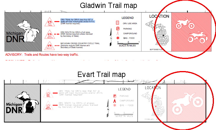
The Evart trail map shows it's designation by the presence of only a motorcycle in the picture on the lower right hand corner. If it were an ATV accessible trail it would have a picture of both a cycle and an ATV (see Gladwin map for example). The name of the trail also can aid in determination of a trail - "Evart Motorcycle Trail" vs "Gladwin ORV Trail". Admittedly the trail name is not 100% consistent, but the picture in the lower right is. There are certainly better ways to convey this information to the general riding public.

I'm having a hard time seeing where you are getting a "clearly defined difference" of the trail in the Guidebook. They show the types of trail markers you may encounter but the markers do not designate the type of trail - all the ORV trail markers are used interchangeably on the ground.
As for the statement from Steve about it being illegal to ride an ATV on the Evart trail, I think there was some misunderstanding. He knows it's not illegal to ride an ORV on an ORV trail and Evart certainly is an ORV trail. Michigan has no legislation that makes it illegal for an ATV to be on an ORV trail that's maintained to 40" specs. IF that ATV has to leave the trail or damage the trees to navigate the trail, than that act is illegal, but if they can fit, it is legal for them to be on it.
 

Tom Cox

Member
May 16, 2003
59
0
Well to throw my 2 cents in the ring, being an out of stater and traveling to MI every year to ride, we look at the maps and ride only the trails with a motorcycle symbol in the bottom right hand corner. This month we're headed to the upper peninsula again. Yes I'm a member of CCC. Got to support the people that make it happen.
 

duckboy

Member
Jan 9, 2005
200
0
2TrakR said:
duckboy,
The Evart trail map shows it's designation by the presence of only a motorcycle in the picture on the lower right hand corner. If it were an ATV accessible trail it would have a picture of both a cycle and an ATV
Then why does it say motocycles and atv's?

2TrakR said:
duckboy,
(see Gladwin map for example). The name of the trail also can aid in determination of a trail - "Evart Motorcycle Trail" vs "Gladwin ORV Trail". Admittedly the trail name is not 100% consistent, but the picture in the lower right is.
If the picture is always 100% correct then why is there a picture of a motorcycle and not an atv for Gladwin?

2TrakR said:
duckboy,
There are certainly better ways to convey this information to the general riding public.
You are absolutely right.

2TrakR said:
duckboy,
I'm having a hard time seeing where you are getting a "clearly defined difference" of the trail in the Guidebook.
Cycle Trails on page 11 don't include atv's in the description. Show me one example of a DNR map with a cycle trail that doesn't say motorcycles and/or atv's.

2TrakR said:
duckboy,
They show the types of trail markers you may encounter but the markers do not designate the type of trail - all the ORV trail markers are used interchangeably on the ground.
I have no idea why you would think that the markers have nothing to do with marking the trails designation. If that were true why are they not just blank orange triangles?

2TrakR said:
duckboy,
As for the statement from Steve about it being illegal to ride an ATV on the Evart trail, I think there was some misunderstanding. He knows it's not illegal to ride an ORV on an ORV trail and Evart certainly is an ORV trail.
Then why when I talked to him did he say it was motocycles only? Can anybody keep there stories straight? Can any body else show where they get there information besides me? You and Steve seem to have alot of opinions on what the maps, legislation and orv book say, but have either of you shown me proof, as in black and white? If any of what you say is true then why is this information not readily available in the orv handbook or on the maps?

2TrakR said:
duckboy,
Michigan has no legislation that makes it illegal for an ATV to be on an ORV trail that's maintained to 40" specs. IF that ATV has to leave the trail or damage the trees to navigate the trail, than that act is illegal, but if they can fit, it is legal for them to be on it.
Prove it..........geez most maps eliminate confusion.
 

ellandoh

dismount art student
~SPONSOR~
Mi. Trail Riders
Aug 29, 2004
2,958
0
Duckboy, you need to be on a committee somewhere , you know your technicalities it sounds like to me.
while im here id like to know if theres a way to get a hold of a map of all the different systems in MI or do i have to download them from home or stop at the nearest DNR office of the trail im going to ?
 

2TrakR

~SPONSOR~
Mi. Trail Riders
Jan 1, 2002
794
0
ellandoh said:
id like to know if theres a way to get a hold of a map of all the different systems in MI or do i have to download them from home or stop at the nearest DNR office of the trail im going to ?

Maps of the trail systems are available in the following ways that I know of:
DNR web (you know this already)
Local DNR field office (you know too; this is getting more difficult to obtain due to budget constraints though).
Commercial product available at some ATV dealers that has large format trail maps of the lower peninsula in a "gazetteer" style product. I saw them at Linwood Cycle & they were ~$19. Published by Off Road Ventures; not sure where else you can get these.
Cycle Conservation Club map book - free with membership. Covers all ORV trail systems in Michigan including those that the DNR does not have available (sections of the MCCCT for example). Updated for 2005 with trail depictions based on GPS data, full color.
 

ellandoh

dismount art student
~SPONSOR~
Mi. Trail Riders
Aug 29, 2004
2,958
0
i am planning a gps in the near future and am glad to hear of higher guality maps . MCCC sounds like the way to go , from what ive read in a thread here they have downloadable directly into the GPS available for members also
 

2TrakR

~SPONSOR~
Mi. Trail Riders
Jan 1, 2002
794
0
2TrakR said:
The Evart trail map shows it's designation by the presence of only a motorcycle in the picture on the lower right hand corner. If it were an ATV accessible trail it would have a picture of both a cycle and an ATV

duckboy said:
Then why does it say motocycles and atv's?

Motorcycles and ATVs are both Off Road Vehicles (ORVs) and are both generally in the under 50 inch in width category. Both generally meet the legal requirements to operate on an ORV trail. The language used to define an ORV trail includes ANY off road vehicle that's under 50" and both cycles and ATVs fit in that category. They should change the language on the maps to make it more clear who the target User group of the trail is. Even so, the language used is true and accurate even if it does not best describe the trail's normal usage.
Pretend you are some mucky muck in Legal who has to approve the language used on all publications, in this case it would be a map. You have no clue about ATVs or cycles or single track for that matter. The best you can find is the legal definition of an ORV Trail and the legal definition of an ORV. Based on that information, you approve what is on the DNR maps because:
An ORV Trail is for ORVs 50" or less in width.
An ORV is (list of things) including ATVs and Motorcycles, which are also the primary vehicles that are less than 50" in width.

2TrakR said:
(see Gladwin map for example). The name of the trail also can aid in determination of a trail - "Evart Motorcycle Trail" vs "Gladwin ORV Trail". Admittedly the trail name is not 100% consistent, but the picture in the lower right is.

duckboy said:
If the picture is always 100% correct then why is there a picture of a motorcycle and not an atv for Gladwin?

Are we looking at different maps? The Gladwin Trail map from the DNR has both an ATV and a Motorcycle in the lower right hand picture. Just double checked here.

2TrakR said:
I'm having a hard time seeing where you are getting a "clearly defined difference" of the trail in the Guidebook.

duckboy said:
Cycle Trails on page 11 don't include atv's in the description. Show me one example of a DNR map with a cycle trail that doesn't say motorcycles and/or atv's.

There are no examples of which you request. Two reasons for this: there is no "cycle trail" - it's all ORV Trail; there is only one definition of an ORV Trail and that same language is used on all the maps.

2TrakR said:
They show the types of trail markers you may encounter but the markers do not designate the type of trail - all the ORV trail markers are used interchangeably on the ground.
duckboy said:
I have no idea why you would think that the markers have nothing to do with marking the trails designation. If that were true why are they not just blank orange triangles?

The triangles that have an ATV on them are used interchangeably with those that have a cycle on them. I know this as I perform trail maintenance and install trail markers. We use the type and style of triangles that are made available to us by the Department. These triangles differ from ORV Route and MCCCT triangles and are not used interchangeably with them. Only the ORV Trail markers fit this category. I think, and bet you agree, that the markers with a cycle should only be used on trails maintained at 40" and the ones with ATVs should only be used on trails maintained at 50". But as I indicated, this has not been the case.

2TrakR said:
As for the statement from Steve about it being illegal to ride an ATV on the Evart trail, I think there was some misunderstanding. He knows it's not illegal to ride an ORV on an ORV trail and Evart certainly is an ORV trail.

duckboy said:
Then why when I talked to him did he say it was motocycles only? Can anybody keep there stories straight? Can any body else show where they get there information besides me? You and Steve seem to have alot of opinions on what the maps, legislation and orv book say, but have either of you shown me proof, as in black and white? If any of what you say is true then why is this information not readily available in the orv handbook or on the maps? Prove it.........

Well, hang on a second. Did Steve say "motocycles only" or did he say "it's illegal for ATVs to ride the Evart trail"? It may sound like I'm picking on semantics but there is a big difference between the quotes.

Now let's work on the proof you want.
Start here: http://www.state.mi.us/orr/emi/admincode.asp?AdminCode=Single&Admin_Num=29900921&Dpt=NR&RngHigh=

ORV Trail Legal definition:
"Designated trail" means a 1-track path or way which is capable of
travel by a 2- to 4-wheel vehicle that is less than 50 inches in width and
which has been properly signed on the ground for ORV use.

ORV is legally defined as (excerpt):
"ORV" includes, but is not limited to, any of the following:
(ii) A motorcycle or related 2-wheel or 3-wheel vehicle.

With the above, we now have a legal definition of ORV Trail. There is NO other legal definition of such a trail that pertains to width or allowed usage - meaning there is no "Cycle Trail" or "ATV Trail". Note I'm excluding ORV Route in this discussion.
Based on this information I know that it's legal to ride my 49" ATV down any posted open ORV Trail.

On any of the DNR maps, the ORV trail is defined as:
ORV TRAIL-for ORV's less than 50" in width-off road motorcycles and/or ATV's.

Which is in accordance with the above listed legal descriptions, right?
Flip of the coin for a second - if you just went by what the map said you could be lead to believe that it would be illegal to drive your 49" wide golf cart on an ORV Trail. This would be inaccurate and to prove it we go back to the legal definition of a Designated Trail which allows vehicles that are not cycles or ATVs.

Back to the topic at hand.
Would it be illegal to drive your ATV on the Evart Trail? Only if you were to go off the designated trail to navigate it. For example, the trail passes between two trees that are 43" apart and your ATV is 48", so you leave the trail and drive around them. The law says this is illegal:
To destroy, damage, or remove trees, shrubs, wildflowers, grasses, or
other vegetation.
To use or operate any wheeled, motorized vehicle in the Upper Peninsula
of this state, except on a designated route, a designated trail, a designated
area, or a forest road not otherwise posted as closed to the use of motorized
vehicles or entry.
To use or operate any wheeled, motorized vehicle in the Lower Peninsula
of this state, except on a designated route, a designated trail, or a
designated area. A wheeled, motorized vehicle that is properly registered
under 1949 PA 300, MCL 257.1 et seq. may be operated on a forest road not
otherwise posted as closed to the use of motorized vehicles or entry.

By leaving the designated trail/path you are in violation of the latter two paragraphs (it's considered cross country travel).

"Yeah, but Steve said motorcycles only". Which he should have. What if he said to go ahead and ride your ATV on the Evart trail? He knows that trail is maintained at 40" and knowing that, he can assume there will be places an ATV will not fit. He may not know this for a fact, but it's a reasonable assumption. Now that he told you ride your ATV on that trail you can come back to him when you get a ticket for driving off-trail to get through the tighter areas. While the LEO is writing the ticket you can say "Yeah, but Steve said I could ride my quad on this trail". Then you'll be yelling at him at the next (not cancelled) ORV Advisory Board meeting 'cause you got a ticket for doing what he said you could do.

Much easier to say "That trail is maintained for motorcycles only" all the while being completely true and honest.


:laugh:
 

2TrakR

~SPONSOR~
Mi. Trail Riders
Jan 1, 2002
794
0
ellandoh said:
MCCC sounds like the way to go , from what ive read in a thread here they have downloadable directly into the GPS available for members also

I've not made it available yet, but it will be in another month or so. We're still field testing the GPS maps and struggling with the Magellan version (Garmin is functional).
There most likely will be a charge for the GPS version of things, but it's just to cover the cost of the CDs & postage. The physical paper mapbook is included as part of the membership package.

/Jeramey
CCC Mapping Coordinator
 

ellandoh

dismount art student
~SPONSOR~
Mi. Trail Riders
Aug 29, 2004
2,958
0
2TrakR said:
I've not made it available yet, but it will be in another month or so. We're still field testing the GPS maps and struggling with the Magellan version (Garmin is functional).
There most likely will be a charge for the GPS version of things, but it's just to cover the cost of the CDs & postage. The physical paper mapbook is included as part of the membership package.

/Jeramey
CCC Mapping Coordinator

alright :) would it be safe to get a Magellan ,, i was looking towards the sportrak color but will look for equivalent in Garmin if thats what MCCC is able to work with only

THANKS L+O
 

WildBill

~SPONSOR~
Mi. Trail Riders
Mar 29, 2002
281
0
2TrakR,

Not to get off topic, but since you mentioned it, will the '05 CCC mapbooks be mailed soon? I couldn't make ROS to pick up in person and my mapbbok is pretty beat up. Thanks for all you r efforts...
 

FLEM

Member
Sep 22, 2004
70
0
2trakR, I got to give you guys a big thumbs up on the new mapbooks, very cool. Has there been anymore discussion on doing a 11 X 17 version, I'd be intwerested even if its an extra charge. It'll just make it that much better.
 

2TrakR

~SPONSOR~
Mi. Trail Riders
Jan 1, 2002
794
0
ellandoh - Garmin is a safe bet & if the CCC GPS maps are what you are after it may be a better choice. Magellan makes good units too...

WildBill - The 05 mapbooks will be mailed soon. I think the process is already underway.

Flem - thanks for the good word on the mapbook. We've not discussed a larger version since we originally settled on the current format (price was a big issue). Historically we've printed the mapbook every two years so the conversation about future changes hasn't happened yet. I'll make sure it's on the discussion list though.
 

duckboy

Member
Jan 9, 2005
200
0
http://www.michigan.gov/dnr/1,1607,7-153-10365_15070_15080-38330--,00.html
This link has exactly the same maps available from the dnr to the general public. Maybe if you actually looked at the Gladwin map you would see there is no picture of an atv. Also if you actually look at the evart map you would see it says 50" and not 40". MAPS SHOULD GIVE ACCURATE INFORMATION AND ELIMINATE CONFUSION. These maps do not and if you think it's OK that people have to go to the trail to see if it's actually maintained at 50" you need to get you head out of your @$$.
 

2TrakR

~SPONSOR~
Mi. Trail Riders
Jan 1, 2002
794
0
duckboy,

No better way to not get something accomplished than to lose your temper, or so I hear.
Here's what I'm referring to on the maps regarding the image in the lower right hand corner. Does the map you have differ in it's depiction?
map_image_example.jpg


As for my opinion on what the map should depict, I've already stated that the DNR doesn't do as good of a job that should/could be done. They do, however, have accurate information on their maps and do, contrary to what you seem to believe, indicate what vehicle is best suited for use on a given trail.

If you really do want the data on those maps changed, it's best to understand what is on them currently and what everything on those maps represents. Otherwise it's just going to be a p|ssing match with them and you will get nowhere.
 
Top Bottom